
File:Ukivok.jpg

Size of this preview: 800 × 525 pixels. Other resolutions: 320 × 210 pixels | 640 × 420 pixels | 1,024 × 672 pixels | 1,280 × 840 pixels | 1,804 × 1,184 pixels.
Original file (1,804 × 1,184 pixels, file size: 1.38 MB, MIME type: image/jpeg)
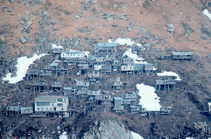
| Description | The stilt village of Ukivok - this is now deserted. Located on King Island in the Bering Strait. |
| Date | |
| Source | http://www.photolib.noaa.gov/htmls/line0188.htm |
| Author | Captain Budd Christman, NOAA Corps |
| Permission (Reusing this file) |
public domain |
| Camera location | | View this and other nearby images on: OpenStreetMap |
|---|
This image is in the public domain because it contains materials that originally came from the U.S. National Oceanic and Atmospheric Administration, taken or made as part of an employee's official duties.
|
File history
Click on a date/time to view the file as it appeared at that time.
| Date/Time | Thumbnail | Dimensions | User | Comment | |
|---|---|---|---|---|---|
| current | 19:36, 22 Siqiññaatchiaq 2009 | | 1,804 × 1,184 (1.38 MB) | CharlotteWebb |
File usage
The following page uses this file:
Global file usage
The following other wikis use this file:
- Usage on az.wikipedia.org
- Usage on en.wikipedia.org
- Usage on it.wikipedia.org
- Usage on pt.wikipedia.org
- Usage on tr.wikipedia.org
- Usage on zh.wikipedia.org